Preliminary plans had been formulated by Toole Design Group with the help of community and advocate input over two chilly nights in February. I described those meetings here:
Blog post on February Meetings


Before their revised plans were revealed, traffic modeling was reviewed, community comments were considered, and revisions were made to the plans.

Toole reviewed the traffic data for the meeting, which showed a few quirks known well to locals: the a.m. peak traffic tends to be split between the center lanes and carriage road, while in the p.m. peaks the geometry of the existing roadways at Kelley Circle sends most of the traffic along the carriage road side, close to the abutting homes. The traffic counts in the chart above were done prior to the Casey-Arborway construction, and reflect typical expected peak volumes.
Blog post on February Meetings


Before their revised plans were revealed, traffic modeling was reviewed, community comments were considered, and revisions were made to the plans.

In February Toole's research showed that high rates of vehicle speed and poor road design was contributing to an extraordinarily large number of crashes:

Toole then took time to review the safety benefits of modern roundabouts in parkway situations such as these. Signalized intersections can create many points of conflict while modern roundabouts create fewer, which can lead to safer conditions for all modes - cars, bikes and pedestrians:


Project heads announced a phased plan for the project, stating that improvements south of Murray Circle towards Forest Hills - including the Arborway Frontage Road opposite the Arboretum - would have to wait for "Phase 2" because of grading differentials on the mainline Arborway lanes that make that portion of the project more complex and expensive than first anticipated.


That prohibition should not (but does currently) delay the installation of two raised-table crosswalks on the Arborway Frontage Road proposed in the initial design: one at the Hunnewell Gate/Arboretum crosswalk and another proposed at St. Rose Street to cross to the Arborway Hillside trail. That crosswalk was inserted to slow vehicles coming down the Arborway Hillside and to create connectivity towards the Forest Hills Gate of the Arboretum and new Casey-project sidewalks to be built on the eastern side of the Arborway next year.
For now, the main project area is as follows (in all these maps, North is to the right where Jamaica Pond lies):


The revised plan took into consideration community input and local objections to some of the original ideas floated, and now maintains both Prince and Orchard Streets as existing one-ways southbound. Toole also re-evaluated how the Pond/Prince/Parkman roadways interact west of Kelley Circle (towards the top of the image above).


Project heads announced a phased plan for the project, stating that improvements south of Murray Circle towards Forest Hills - including the Arborway Frontage Road opposite the Arboretum - would have to wait for "Phase 2" because of grading differentials on the mainline Arborway lanes that make that portion of the project more complex and expensive than first anticipated.


That prohibition should not (but does currently) delay the installation of two raised-table crosswalks on the Arborway Frontage Road proposed in the initial design: one at the Hunnewell Gate/Arboretum crosswalk and another proposed at St. Rose Street to cross to the Arborway Hillside trail. That crosswalk was inserted to slow vehicles coming down the Arborway Hillside and to create connectivity towards the Forest Hills Gate of the Arboretum and new Casey-project sidewalks to be built on the eastern side of the Arborway next year.
For now, the main project area is as follows (in all these maps, North is to the right where Jamaica Pond lies):


The revised plan took into consideration community input and local objections to some of the original ideas floated, and now maintains both Prince and Orchard Streets as existing one-ways southbound. Toole also re-evaluated how the Pond/Prince/Parkman roadways interact west of Kelley Circle (towards the top of the image above).
In the current plans, the Carriage Roads between the existing rotaries become one-way roads that travel in opposite directions from the nearest center lanes of the Arborway. All thru-traffic will be directed towards these center lanes. Bike lanes between the roundabouts will be created on the median side of the Carriage Roads, which will now carry loads more comparable to a neighborhood street than to a busy thoroughfare. For that reason, Toole has recommended that these bike lanes between the roundabouts be painted lanes rather than fully protected (other than by virtue of their placement in a 'local traffic only' one-way street). There was considerable blowback on this lack of physical separation from the bike advocacy community in attendance.

Reconfiguring the roadways with traffic calming features added is expected to slow down the speed of traffic within the project area, but the elimination of three traffic signals is expected to lead to very similar end-to-end travel times. The proposed roundabouts and access routes reduce conflict points between vehicles, pedestrians and bikes while also creating conditions for an orderly flow of traffic at peak volumes. Northbound Arborway "slip lanes" have been added near the rotaries since the February plan, allowing a single lane of thru-traffic to avoid the rotaries entirely (but not the crosswalks).
This image of the revised Kelley Circle near the pond help illustrate many notable features:

Pedestrian sidewalks are shown in black. Bike paths between the sidewalks and roadways are yellow. Every crosswalk and bike crossing is a raised-table: low and wide humps which slow vehicles to speeds estimated by Toole to be 20 mph rather than the 45 mph and more typically experienced in the corridor. Pedestrians and bikes cross where cars are traveling at their slowest. Deflection islands for entering and exiting roadways at the roundabouts encourage cars to stay in their lanes and change directions at slow speeds. The central islands have wide aprons around them to allow for larger emergency vehicles like firetrucks. The surface of the roads is "reversed-cambered". Rather than tilt into the curve as they would on an interstate highway they tilt outward, which tends to discomfort drivers traveling at speed and leads to safer and slower travel. All intersections on the main corridor and roundabouts of the project area are "Yield-controlled" rather than signal controlled - the plan eliminates three traffic signals:

The Murray Circle Rotary is to be reconfigured as a modern Dual Roundabout which slows traffic, reduces conflict and serves the needs of all users. In the western lobe, Centre Street heads towards Faulkner Hospital in the top left corner. As with the Kelley Circle drawings, pedestrian sidewalks are black and off-street bike lanes are yellow, with raised-table crosswalks where traffic is slowest. There is a large deflection/refuge island between the two Murray Roundabouts.

The Arborway continues toward the lower left. Centre Street enters from the Monument area at the bottom, and Prince and Orchard enter from the right.
Toole Design Group produced two animated renderings showing the performance of these proposed roundabouts during Peak AM and Peak PM periods based on actual observed data:
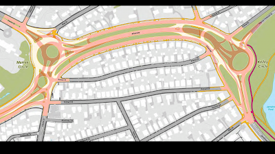
This image shows an overlay of how the new configuration is built from the old. White shows the existing roadways while orange shows the new design:
Bicycle routes are shown here. Safe off-street bike lanes everywhere except between the roundabouts where they are on the newly calmed local traffic carriage roads:

Pedestrian routes shown here, with crossings via raised-table crosswalks:


The reconfiguration of Greenspace is shown in this rendering:

The tentative timetable for the project was outlined as follows:

DCR is seeking public comments on this proposal through November 5, 2015. DCR's page for public meetings, with an opportunity to review materials, presentations and provide input during the comment period is available here (you can scroll down to February 3 & 5 for the extensive material from the first round of meetings):DCR's public meetings page link

Reconfiguring the roadways with traffic calming features added is expected to slow down the speed of traffic within the project area, but the elimination of three traffic signals is expected to lead to very similar end-to-end travel times. The proposed roundabouts and access routes reduce conflict points between vehicles, pedestrians and bikes while also creating conditions for an orderly flow of traffic at peak volumes. Northbound Arborway "slip lanes" have been added near the rotaries since the February plan, allowing a single lane of thru-traffic to avoid the rotaries entirely (but not the crosswalks).
This image of the revised Kelley Circle near the pond help illustrate many notable features:

Pedestrian sidewalks are shown in black. Bike paths between the sidewalks and roadways are yellow. Every crosswalk and bike crossing is a raised-table: low and wide humps which slow vehicles to speeds estimated by Toole to be 20 mph rather than the 45 mph and more typically experienced in the corridor. Pedestrians and bikes cross where cars are traveling at their slowest. Deflection islands for entering and exiting roadways at the roundabouts encourage cars to stay in their lanes and change directions at slow speeds. The central islands have wide aprons around them to allow for larger emergency vehicles like firetrucks. The surface of the roads is "reversed-cambered". Rather than tilt into the curve as they would on an interstate highway they tilt outward, which tends to discomfort drivers traveling at speed and leads to safer and slower travel. All intersections on the main corridor and roundabouts of the project area are "Yield-controlled" rather than signal controlled - the plan eliminates three traffic signals:

The Murray Circle Rotary is to be reconfigured as a modern Dual Roundabout which slows traffic, reduces conflict and serves the needs of all users. In the western lobe, Centre Street heads towards Faulkner Hospital in the top left corner. As with the Kelley Circle drawings, pedestrian sidewalks are black and off-street bike lanes are yellow, with raised-table crosswalks where traffic is slowest. There is a large deflection/refuge island between the two Murray Roundabouts.

Toole Design Group produced two animated renderings showing the performance of these proposed roundabouts during Peak AM and Peak PM periods based on actual observed data:
This image shows an overlay of how the new configuration is built from the old. White shows the existing roadways while orange shows the new design:

Bicycle routes are shown here. Safe off-street bike lanes everywhere except between the roundabouts where they are on the newly calmed local traffic carriage roads:

Pedestrian routes shown here, with crossings via raised-table crosswalks:


The reconfiguration of Greenspace is shown in this rendering:

The tentative timetable for the project was outlined as follows:

DCR is seeking public comments on this proposal through November 5, 2015. DCR's page for public meetings, with an opportunity to review materials, presentations and provide input during the comment period is available here (you can scroll down to February 3 & 5 for the extensive material from the first round of meetings):DCR's public meetings page link


